

Augmented reality is coming to Google Maps.
Search giant Google said on Monday that it is testing an update to the on-the-go navigation feature in its Google Map app, so you can use your phone’s camera and on-screen arrows to help you find your way. The company also first announced the feature at its I/O developer conference in May, but it said on Monday that it is rolling out the update to a small number of the app’s Local Guides, which are a number of Google Maps users who voluntarily contribute local information about businesses and test new features.
Google said that it does not have a timetable for issuing the new update, and the goal of this new feature is to help you orient yourself when you follow the map and help solve the problem of inconvenience common in many major cities. An example of this is that you can get out of the subway, for example, and you have no idea of the way, so you are waiting for a small blue dot in the application to direct you in the right direction.
This announcement comes at a time when Google is adding more capabilities to the Maps application, which has more than a billion users, as Google announced last May. Google also announced features to make the application more social, such as the “For You” tab that offers personalized recommendations and a “Match Score” to tell you how much you like a restaurant or business.
Google Maps is also expanding its partnerships, as in December it was partnering with electric scooter company Lime to show you where the nearest scooter is parked.
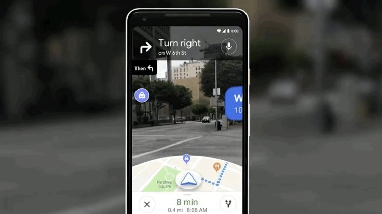
Here’s how the new navigation feature works:
Enter an address or business into the Google Maps app, switch to walking directions mode, and tap a button to launch AR functionality. (Augmented reality through a smartphone camera). As the Pokemon Go game used to work before, note that you will see the camera view at the top of the screen and a traditional map at the bottom. When you approach Manal Duran, the phone will vibrate and there will be arrows on the screen to direct you. The idea is not to hold your phone in front of you.
As a side note, Kim also pointed out that the feature sometimes doesn’t work accurately in the dark, and for the feature to work as intended, Google will collect data from cell towers and satellites in addition to the information Google provides from Street View maps.
When Google showed off an explainer video of AR trends at its I/O conference in May, the company also showed off an animated 3D fox to guide you on your way. This feature won’t be released for testing. One reason for the lack of this feature is that the small fox might act as a distraction for people holding their phones in front of them.
At the conference, the company also teased that Maps will integrate with Google Lens, the company’s visual search tool, to display information about businesses around you, again through the phone’s camera, but that product is still in the prototype stages, Kim said Monday.


